


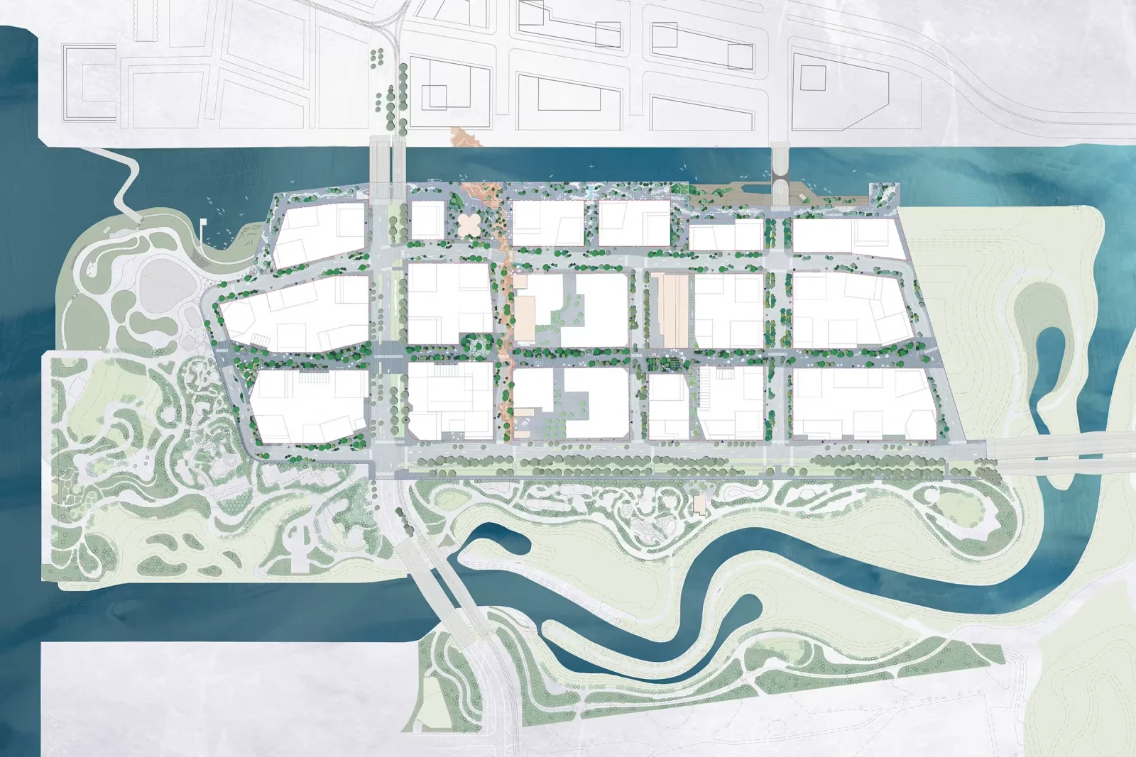
Toronto’s waterfront transformation continues to take shape with the unveiling of the public realm and streetscape design for Ookwemin Minising, a new island community emerging within the Port Lands district in Toronto. Led by Danish landscape and urban design studio SLA in collaboration with engineering firm GHD and Waterfront Toronto, the project proposes a nature-led framework where streets, ecology, infrastructure, and public life are conceived as one interconnected system. The development marks one of North America’s urban regeneration initiatives, transforming former industrial lands into a mixed-use waterfront neighborhood centered on resilience, biodiversity, and everyday urban experience.

Formerly known as Villiers Island, Ookwemin Minising takes its name from the Anishinaabemowin language, meaning “place of the black cherry trees.” The island was created through the Port Lands Flood Protection project, a large-scale environmental restoration effort that naturalized the mouth of the Don River while introducing flood protection infrastructure across Toronto’s eastern waterfront. Planned as the first new community within the wider Port Lands revitalization framework, the district is expected to support approximately 21,000 residents alongside commercial, cultural, and recreational spaces.


At the center of the proposal is SLA’s “Growing Streets” concept, an urban design strategy that prioritizes public spaces and streetscapes as the foundation of city-making. The project reimagines them as living ecological systems capable of managing stormwater, reducing urban heat, supporting biodiversity, and creating social gathering spaces simultaneously. Rainwater capture, filtration, and reuse are embedded directly into the streetscape through green infrastructure systems, while extensive planting strategies introduce habitats for native species and improve seasonal microclimates throughout the district.

SLA, known internationally for integrating landscape architecture with ecological urbanism, serves as the design lead for the urban realm and landscape strategy. The Copenhagen-based studio has previously worked on large-scale climate-adaptive public spaces across Europe and North America, often emphasizing nature-based infrastructure and social sustainability. For Ookwemin Minising, the studio collaborated closely with GHD, which acts as the project’s prime consultant and technical lead, combining engineering systems with public-space design to create infrastructure that is both performative and civic in character.

The streetscape framework is structured around five major design strategies: Living Legacy, Local Character, Prioritize Nature, Strategic Density, and Everyday Mobility. Together, these principles shape six distinct public-realm character areas across the island. The masterplan emphasizes walkability and soft mobility through pedestrian-focused streets, cycling routes, ecological corridors, and climate-responsive landscapes woven into daily urban life. Centre Commons, positioned as the project’s social and ecological spine, stretches approximately 760 meters across the island and is envisioned as Canada’s longest year-round pedestrianized public space. The linear commons will contain around 400 trees alongside gathering spaces, ecological planting zones, and recreational infrastructure.

A major aspect of the design lies in its integration of Indigenous knowledge and cultural memory. SLA and the broader design team collaborated with Indigenous co-designers Trophic Design to embed storytelling, landscape heritage, and historical spatial patterns into the public realm. Elements such as Ookwemin Street and the Sandbar Trail reference historic shorelines and Indigenous carrying routes through materiality, alignments, planting, and interpretive interventions. The project integrates cultural narratives directly into the physical and ecological structure of the neighborhood.

The wider multidisciplinary team includes Allies and Morrison as architectural lead, Transsolar for sustainability and low-carbon infrastructure systems, Monumental Projects for public engagement and outreach, and Level Playing Field for accessibility services. Allies and Morrison’s massing strategy reportedly increases density by approximately 27 percent compared to earlier planning models, helping deliver around 12,000 housing units, including 3,000 affordable homes, while maintaining access to open public landscapes and waterfront connections.

Beyond its physical transformation, Ookwemin Minising proposes a new model for waterfront urbanism where climate resilience, mobility, ecological restoration, and civic life are integrated from the earliest stages of planning. The project positions streets as the primary framework through which the city grows, adapts, and connects people with nature. With phased development expected between the early 2030s and 2040, the island community represents an evolving experiment in landscape-led city-building for Toronto’s future waterfront.
Toronto’s Ookwemin Minising Project Details
Project: Ookwemin Minising
Location: Port Lands, Toronto, Canada
Site Area: 39.8 hectares
Design Lead for Urban Realm and Landscape: SLA
Prime Consultant and Technical Lead: GHD
Architectural Lead: Allies and Morrison
Indigenous Landscape Design: Trophic Design
Sustainability and Low-Carbon Systems: Transsolar
Client: Waterfront Toronto, The City of Toronto, CreateTO
Project Type: Waterfront Urban Redevelopment / Public Realm Design
Expected Completion: 2025—2036
Housing Capacity: Approx. 12,000 units
Affordable Housing: Approx. 3,000 units
Planned Population: Approx. 21,000 residents
Credit: SLA
Explore Courses

.jpg "Ondrej Chybik - Rethinking Architecture")


